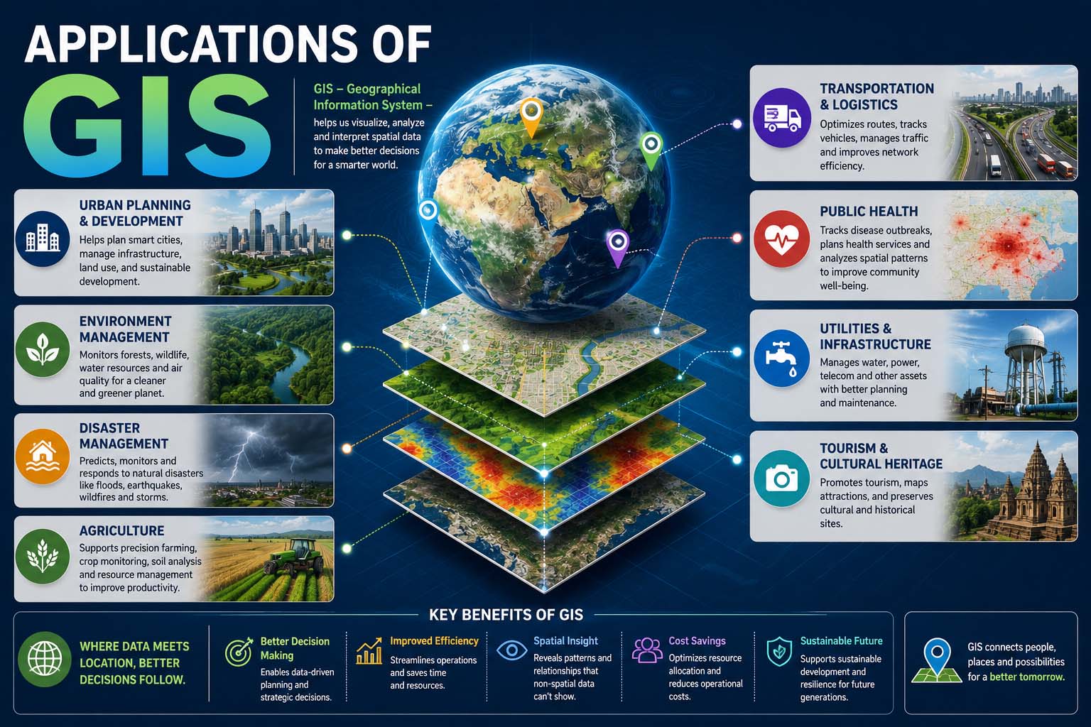
Location plays a role in almost every decision we make, from finding the fastest route home to planning where a new business should open. That’s why the applications of GIS have become so valuable across both public and private sectors. Geographic Information Systems (GIS) combine maps with data, helping organizations understand patterns, solve problems, and make smarter decisions based on location.
Today, GIS is used for everything from city planning and farming to disaster response and logistics. As cloud computing, artificial intelligence, and satellite technology continue to evolve, GIS platforms have become faster, more accurate, and easier to use than ever before.
What Is GIS?
A Geographic Information System (GIS) is a technology that captures, stores, analyzes, manages, and visualizes geographic or spatial data.
Unlike a traditional paper map, GIS connects locations with information. For example, a city map can show roads, traffic volume, flood zones, population density, utility lines, and property boundaries all in separate layers.
This layered approach allows users to explore relationships that would otherwise be difficult to identify.
If you’ve ever asked, what are the five applications of GIS, the answer depends on the industry, but the most common areas include urban planning, agriculture, environmental management, transportation, and emergency services.
How the Applications of GIS Work
The applications of GIS rely on collecting geographic data from multiple sources and converting it into useful visual information.
A typical GIS workflow looks like this:
- Collect location-based data from GPS devices, drones, satellites, surveys, or sensors.
- Store the data in a geographic database.
- Organize information into separate map layers.
- Analyze relationships between locations.
- Display the results using interactive maps, dashboards, or reports.
- Use the insights to support planning and decision-making.
Many organizations also improve data quality through etl process optimization, ensuring location information from different systems is cleaned, transformed, and combined before being analyzed.
Key Components of a GIS System
Every GIS platform includes several essential elements.
| Component | Purpose |
|---|---|
| Geographic Data | Maps, satellite images, GPS coordinates |
| Database | Stores spatial and attribute data |
| GIS Software | Performs mapping and analysis |
| Hardware | Computers, servers, mobile devices |
| Users | Analysts, planners, engineers, researchers |
| Data Collection Tools | GPS devices, drones, sensors |
Together, these components allow organizations to transform raw geographic information into meaningful insights.
Applications of GIS in Agriculture
One of the fastest-growing uses is the applications of GIS in agriculture.
Modern farms generate enormous amounts of data from satellites, weather stations, drones, and smart equipment. GIS combines this information to improve crop production while reducing waste.
Farmers use GIS to:
- Monitor crop health
- Analyze soil quality
- Plan irrigation systems
- Track fertilizer usage
- Predict harvest yields
- Detect pest outbreaks
- Optimize planting schedules
Instead of treating an entire field the same way, farmers can manage individual sections based on real-time conditions.
This approach supports precision agriculture, increasing productivity while lowering operating costs.
Urban Planning and Smart Cities
Cities rely heavily on GIS for planning future development.
Urban planners analyze information such as:
- Population growth
- Road networks
- Public transportation
- Utility infrastructure
- Land use
- Green spaces
- Flood risk
GIS helps governments decide where schools, hospitals, roads, and parks should be built.
When designing environmentally sustainable communities, planners often evaluate ecosystems alongside urban expansion. Learning what is a biodome also provides useful context for understanding how controlled environments and ecological planning can complement GIS-based environmental research.
Transportation and Logistics
Transportation companies use GIS every day.
Applications include:
- Route optimization
- Fleet management
- Delivery tracking
- Traffic monitoring
- Public transportation planning
- Fuel consumption analysis
Ride-sharing companies, delivery services, and shipping organizations depend on GIS to improve efficiency while reducing travel time.
Real-time mapping also allows drivers to avoid accidents, road closures, and congestion.
Environmental Monitoring
Environmental scientists use GIS to study natural resources and monitor changes over time.
GIS supports:
- Forest management
- Wildlife conservation
- Flood prediction
- Air quality analysis
- Water resource management
- Climate research
- Coastal erosion monitoring
Satellite imagery combined with GIS allows researchers to compare environmental conditions across months or even decades.
Emergency Response and Disaster Management
Emergency agencies depend on accurate location data during disasters.
GIS helps responders:
- Identify evacuation routes
- Locate shelters
- Map wildfire spread
- Predict flood zones
- Coordinate rescue operations
- Monitor hurricanes
- Assess infrastructure damage
Interactive maps allow decision-makers to allocate emergency resources quickly when every minute matters.
Healthcare and Public Health
Hospitals and health agencies also use GIS to improve public health planning.
Examples include:
- Disease outbreak tracking
- Hospital location planning
- Ambulance routing
- Healthcare accessibility analysis
- Vaccination campaigns
- Environmental health monitoring
By visualizing health data geographically, officials can identify communities that need additional resources.
Five Key Applications of GIS in the Insurance Industry
The five key applications of GIS in the insurance industry demonstrate how location intelligence helps reduce financial risk.
These include:
- Property risk assessment
- Flood and wildfire exposure analysis
- Premium calculation based on geographic risk
- Claims verification after disasters
- Fraud detection using spatial analysis
Insurance companies can evaluate natural hazards more accurately before issuing policies while improving claim investigations after severe weather events.
Business Intelligence and Retail Planning
Businesses use GIS to make better commercial decisions.
Retailers analyze customer locations alongside demographic information to choose profitable store locations.
Common business uses include:
- Market analysis
- Site selection
- Customer segmentation
- Sales territory planning
- Competitor mapping
- Supply chain optimization
GIS also contributes valuable geographic insights to broader performance analytics, allowing organizations to measure regional sales trends, customer behavior, and operational efficiency.
Applications of Artificial Intelligence in GIS
Artificial intelligence has significantly expanded GIS capabilities.
The applications of artificial intelligence in GIS include automated image recognition, predictive modeling, object detection, and real-time spatial analysis.
AI-powered GIS systems can:
- Detect buildings in satellite images
- Identify damaged infrastructure
- Predict traffic congestion
- Classify land cover automatically
- Forecast environmental changes
- Analyze drone imagery
These technologies reduce manual work while improving mapping accuracy.
GIS in Engineering and Infrastructure
Engineers use GIS during planning, construction, and maintenance projects.
GIS assists with:
- Utility mapping
- Pipeline routing
- Road construction
- Bridge inspections
- Telecommunications planning
- Renewable energy projects
Engineers can visualize terrain, property boundaries, and underground utilities before construction begins.
In some industrial projects, GIS data also supports documentation and reverse engineering meaning becomes relevant when engineers recreate or analyze existing infrastructure using geographic and spatial information.
Advantages of GIS
Organizations continue investing in GIS because it offers numerous practical benefits.
Better Decision-Making
Maps often reveal patterns that spreadsheets cannot.
Decision-makers gain a clearer understanding of geographic relationships.
Improved Efficiency
GIS reduces manual mapping and speeds up analysis.
Automated workflows also reduce repetitive tasks.
Cost Savings
Optimized routes, smarter resource allocation, and improved planning lower operating expenses.
Stronger Collaboration
Cloud-based GIS platforms allow multiple departments to access the same geographic information simultaneously.
Accurate Visualization
Interactive maps make complex datasets easier to understand for both technical teams and non-technical stakeholders.
Challenges of GIS
Although GIS offers significant advantages, organizations should also consider potential limitations.
Common challenges include:
- High-quality data requirements
- Initial implementation costs
- Staff training
- Privacy concerns
- Data maintenance
- Large storage requirements
- Integration with older systems
Most organizations address these challenges through proper planning and ongoing data management.
Best Practices for Using GIS
To get the most value from GIS, organizations should follow several best practices.
- Keep geographic data updated regularly.
- Verify data accuracy before analysis.
- Use standardized coordinate systems.
- Protect sensitive location information.
- Document data sources.
- Automate repetitive workflows where possible.
- Train users on GIS software and spatial analysis techniques.
- Regularly review map layers for outdated information.
These practices improve reliability and support better long-term decision-making.
GIS and Emerging Technologies
GIS continues evolving alongside other digital technologies.
Today, GIS integrates with:
- Artificial intelligence
- Internet of Things (IoT)
- Cloud computing
- Drone mapping
- GPS systems
- Satellite imaging
- Digital twins
For example, autonomous machines increasingly rely on GIS to understand their surroundings. This is one reason why many engineers studying smart automation also explore applications of robotics, where accurate mapping and navigation are essential for autonomous operation.
As these technologies mature, GIS will continue providing the geographic intelligence that supports smarter systems.
Frequently Asked Questions
What are the five applications of GIS?
The five most common applications include urban planning, agriculture, transportation, environmental management, and emergency response. Many industries also use GIS for logistics, healthcare, insurance, and business analysis.
Is GIS only used for maps?
No. Maps are only one part of GIS. The technology also analyzes spatial relationships, predicts trends, manages geographic databases, and supports planning through data visualization.
What industries benefit the most from GIS?
Agriculture, government, transportation, construction, environmental science, healthcare, telecommunications, insurance, utilities, and retail all rely heavily on GIS.
Can small businesses use GIS?
Yes. Many cloud-based GIS platforms offer affordable tools that help businesses analyze customer locations, optimize deliveries, and choose better business sites without requiring expensive infrastructure.
Does GIS require programming skills?
Not always. Many GIS applications include user-friendly interfaces with drag-and-drop mapping tools. Advanced users may use scripting or programming languages for automation and custom analysis.
Why GIS Continues to Matter
Geographic Information Systems have become far more than digital mapping tools. They help organizations understand complex relationships between people, places, and resources, making everyday decisions more accurate and data-driven.
As artificial intelligence, cloud computing, drones, and satellite technology continue to improve, the applications of GIS will become even more valuable across industries. Whether optimizing crop production, planning smarter cities, improving disaster response, or helping businesses identify new opportunities, GIS remains one of the most practical technologies for turning location data into meaningful action.