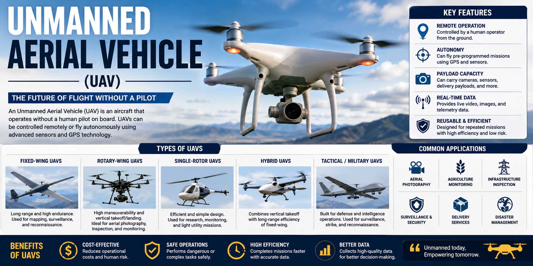
An unmanned aerial vehicle is an aircraft that can fly without a human pilot physically sitting inside it. Instead, a UAV may be controlled remotely by an operator, follow a programmed flight plan, or use onboard systems to perform parts of a flight automatically. Although people often simply call these aircraft drones, UAV technology covers a much broader range of designs, from small camera drones to sophisticated aircraft used for surveying, research, inspection, mapping, and other specialized tasks.
Modern UAVs combine aviation, electronics, sensors, navigation, software, and wireless communication. As a result, they can reach locations that may be difficult, expensive, or inefficient to access using traditional methods.
What Is an Unmanned Aerial Vehicle?
An unmanned aerial vehicle, commonly shortened to UAV, is an aircraft designed to operate without an onboard human pilot. Depending on its design, a person can control it from the ground, while more advanced systems can complete portions of a mission using automated flight controls.
The term UAV unmanned aerial vehicle generally refers to the aircraft itself. However, people sometimes use UAV and drone interchangeably. In everyday conversation, that usually works. In technical settings, though, the terminology can become more specific.
For example, a complete drone operation involves much more than the aircraft. It can include a ground controller, navigation equipment, communication links, software, cameras, sensors, batteries, and supporting equipment.
This combination of mechanical engineering, electronics, control technology, and computing also helps explain what is mechatronics? in a practical context. A modern UAV brings several engineering disciplines together in one working machine.
How Does an Unmanned Aerial Vehicle Work?
Most UAVs follow the same basic process: generate lift, maintain stability, determine their position, receive instructions, and use onboard electronics to control movement.
However, the exact method varies according to the aircraft type.
A multirotor UAV, for instance, uses several propellers to create lift. By changing individual motor speeds, the flight controller can make the aircraft climb, descend, turn, hover, or move in a chosen direction.
Fixed-wing UAVs work differently. Instead, their wings generate lift as the aircraft moves forward. Therefore, they can often cover larger areas efficiently, although they usually cannot hover like multirotor models.
UAV Flight Controller
The flight controller acts as the central control unit of many UAVs. It receives data from sensors and translates operator commands or programmed instructions into aircraft movement.
For example, if wind pushes a hovering drone sideways, its sensors can detect the movement. The controller then adjusts motor output to help correct the aircraft’s position.
This process provides a useful real-world example of open loop vs closed loop control. UAV stabilization commonly depends on feedback because the system continuously measures conditions and responds to changes.
UAV Motors and Propellers
Electric multirotor UAVs commonly use brushless motors because they offer a practical combination of efficiency, responsiveness, and relatively low maintenance.
Understanding brushless motor meaning can therefore help beginners see why these motors are so common in modern drone designs. Unlike traditional brushed motors, they use electronic switching rather than physical brushes for commutation.
Propeller size, shape, pitch, motor choice, aircraft weight, and battery capacity all affect flight performance. Consequently, manufacturers design these components as a matched system rather than choosing each one independently.
UAV Navigation and Positioning
Many UAVs use satellite navigation systems such as GPS or other global navigation satellite systems to estimate location. Meanwhile, onboard sensors may measure altitude, orientation, acceleration, and movement.
Depending on the model, cameras and other sensing systems can also support obstacle detection, positioning, or automated navigation.
However, navigation accuracy varies. Buildings, terrain, interference, weather, equipment quality, and operating conditions can all affect performance.
Main Parts of an Unmanned Aerial Vehicle
Although UAV designs vary widely, several components appear frequently.
The airframe provides the aircraft’s physical structure. Meanwhile, motors or another propulsion system generate the power required for flight. A flight controller manages movement, while sensors provide information about the aircraft and its surroundings.
A typical electric UAV also includes a battery, electronic speed controllers, propellers, antennas, and communication hardware. Likewise, many models carry a payload such as a camera.
Professional aircraft may support more specialized payloads. For instance, a mapping UAV might carry a high-resolution camera or another sensor suited to data collection.
Therefore, buyers should not judge a UAV only by flight time or camera resolution. Payload capacity, positioning capability, software compatibility, operating environment, repairability, and available accessories can matter just as much.
Types of Unmanned Aerial Vehicles
UAVs can be classified in several ways, although aircraft configuration is one of the easiest methods for beginners to understand.
| UAV type | Main strength | Common applications |
|---|---|---|
| Multirotor | Hovering and precise movement | Photography, inspection, close-range surveys |
| Fixed-wing | Efficient long-distance flight | Mapping, agriculture, large-area surveys |
| Single-rotor | Higher payload potential in some designs | Specialized industrial operations |
| Hybrid VTOL | Vertical takeoff plus efficient forward flight | Mapping, inspection, longer-range operations |
Multirotor UAVs
Multirotors include popular quadcopters as well as designs with more than four rotors. Since they can hover and maneuver precisely, they work well for photography, building inspections, and operations in relatively confined areas.
However, hovering requires considerable energy. Therefore, flight endurance can be more limited than with some fixed-wing designs.
Fixed-Wing UAVs
Fixed-wing aircraft resemble conventional airplanes. Because their wings provide lift during forward motion, they can be efficient when covering large distances.
As a result, these UAVs are often suitable for surveying, mapping, environmental monitoring, and agricultural applications.
Hybrid VTOL UAVs
Hybrid vertical takeoff and landing aircraft combine features of multirotor and fixed-wing platforms. For example, they may take off vertically and then transition into forward flight.
That flexibility can be valuable where a runway is unavailable but longer-range operation is still desirable. However, the aircraft and control systems may be more complex.
Unmanned Aerial Vehicle Systems Explained
The phrase unmanned aerial vehicle systems often refers to the wider collection of equipment needed to operate an unmanned aircraft rather than only the aircraft itself. A complete setup can include the UAV, control station, communication link, software, navigation equipment, payload, and supporting hardware.
The Federal Aviation Administration’s definition of an unmanned aircraft system makes a similar distinction: the unmanned aircraft is one component of the wider UAS, which also includes equipment necessary for its safe and efficient operation.
This distinction matters when organizations compare professional systems.
For instance, two aircraft may have similar flight specifications, yet their overall usefulness could differ because one offers stronger mission-planning software, better data processing, more payload choices, or easier integration with existing workflows.
Therefore, organizations buying professional UAV equipment should evaluate the complete operating ecosystem.
Common Unmanned Aerial Vehicle Applications and Uses
UAV technology now supports many civilian and commercial activities. However, the best aircraft depends heavily on the mission.
UAV Mapping and Surveying
UAVs can capture overlapping aerial images that specialized software processes into maps and models. Consequently, surveyors, construction teams, researchers, and land managers can gather visual information across large areas.
Location-based drone data also connects naturally with applications of GIS, since geographic information systems can help organize, visualize, and analyze spatial information collected during aerial surveys.
UAV Infrastructure Inspection
Organizations can use UAVs to inspect roofs, towers, bridges, solar installations, and other infrastructure. In suitable situations, cameras allow operators to examine hard-to-reach areas without placing a person at the same observation point.
Still, UAV inspection does not automatically replace hands-on assessment. Instead, it can provide another source of visual or sensor data for qualified professionals.
Agricultural UAV Applications
Agricultural UAVs can collect aerial imagery that helps farmers and specialists observe fields. Depending on the equipment and workflow, the data may help identify patterns that deserve closer investigation.
Meanwhile, specialized aircraft may support other agricultural tasks where local rules permit them.
Aerial Photography and Video
Consumer drones made aerial photography much more accessible. As a result, UAVs are now common in real estate media, tourism content, filmmaking, event coverage, and landscape photography.
Still, buyers should check local flight restrictions before assuming they can operate a drone at a particular property or event.
UAV Robotics and Automation
A UAV can also be viewed as a flying robotic platform. Therefore, many applications of robotics overlap with drone technology, including remote sensing, automated navigation, environmental monitoring, and inspection.
As sensing and computing improve, UAVs can perform more flight-related tasks automatically. However, automated capability does not necessarily mean unrestricted autonomous operation.
What Is an Unmanned Combat Aerial Vehicle?
An unmanned combat aerial vehicle (UCAV) is a military aircraft designed for combat-related missions without an onboard pilot.
UCAVs are different from typical consumer and commercial drones. They may use specialized military communication, sensing, navigation, and mission systems.
For general technology readers, the key distinction is purpose. Civilian UAVs commonly support photography, inspection, mapping, research, agriculture, and similar applications, while UCAVs are designed around military requirements.
Advantages and Limitations of UAV Technology
UAVs offer several practical advantages. First, they can provide an aerial perspective without requiring a conventional crewed aircraft for every task. Likewise, smaller systems can be deployed relatively quickly in suitable environments.
They can also reach locations that are inconvenient to inspect from the ground. Meanwhile, interchangeable payloads allow some professional platforms to serve several data-collection roles.
However, UAVs have limitations.
Battery-powered aircraft have finite flight time. Likewise, strong wind, rain, temperature, visibility, and other environmental factors can affect operations depending on the model.
Regulations also matter. Airspace rules, registration requirements, operating restrictions, pilot qualifications, and permissions differ between countries and can change over time. Therefore, operators should always check the current rules from the relevant aviation authority before flying.
Privacy and cybersecurity deserve attention as well. Professional operators should manage collected imagery and other data responsibly, while organizations should consider account security, software updates, access control, and data-storage practices.
How to Choose a UAV for a Practical Application
Start with the job rather than the aircraft.
For photography, camera quality, stabilization, portability, and ease of control may be major priorities. Conversely, a mapping operation may care more about flight endurance, positioning, payload compatibility, mission-planning tools, and data-processing workflows.
Next, consider the operating environment. A compact multirotor may suit detailed inspections, whereas a fixed-wing or hybrid aircraft may make more sense for covering a large area.
Then, check the complete cost of ownership. Batteries wear over time, while propellers and other components may require replacement. Professional systems can also involve software subscriptions, training, accessories, insurance, maintenance, and data-processing expenses.
Finally, examine the manufacturer’s support ecosystem. Replacement parts, documentation, firmware support, repair options, compatible accessories, and training resources can significantly affect long-term usability.
Unmanned Aerial Vehicle Operator Jobs and Skills
The growth of commercial drone applications has also created interest in unmanned aerial vehicle operator UAV jobs. Roles can appear in surveying, inspection, photography, mapping, agriculture, media, public-sector operations, research, and other fields.
However, being able to fly a drone is only one part of the job.
Employers may value knowledge of aviation rules, mission planning, weather, risk management, data handling, photography, mapping software, or technical inspection. Depending on the role and country, an operator may also need specific training, certification, registration, or authorization.
Therefore, someone pursuing a UAV career can benefit from combining practical flight skills with expertise in a specific industry.
Frequently Asked Questions About UAVs
Is a UAV the Same as a Drone?
In everyday language, yes, people often use the terms interchangeably. However, UAV is generally a more technical term for an aircraft operating without an onboard human pilot, while “drone” is used more broadly in everyday conversation.
Can an Unmanned Aerial Vehicle Fly Automatically?
Many modern UAVs support automated functions such as waypoint navigation, position holding, or programmed missions. However, capabilities vary significantly between aircraft, and local regulations may limit how certain operations can be conducted.
How Long Can a UAV Fly?
There is no single flight-time figure for all UAVs. Aircraft design, battery or fuel capacity, payload weight, weather, speed, temperature, and mission profile all affect endurance. Therefore, buyers should compare flight specifications under realistic operating conditions.
Do UAVs Always Use GPS?
No. Although many modern UAVs use satellite navigation, aircraft can also rely on inertial sensors, cameras, radio systems, or other navigation technologies. The exact combination depends on the platform and intended application.
Making Sense of UAV Technology
An unmanned aerial vehicle is much more than a remote-controlled flying camera. Instead, it combines an airframe, propulsion, sensors, navigation, communications, software, and control technology into a versatile aerial platform.
For beginners, the easiest way to understand UAVs is to focus on their purpose. Multirotors work well when hovering and precise positioning matter, while fixed-wing designs can suit efficient coverage of larger areas. Meanwhile, hybrid systems aim to combine useful characteristics of both.
As UAV technology continues to develop, the strongest applications will still depend on matching the aircraft, payload, software, operator skills, and regulatory requirements to the job. Therefore, whether you are exploring drones for work, study, or a future career, understanding the complete system is far more useful than comparing aircraft specifications alone.